| |
![]() |
|
| |
The
'Variometer-Plus' deliver exciting values for outdoor sportsmen and
sportswomen - to reach your trip destination. Its a must have app for
paraglider, hang glider, extreme outdoor walkers, sailor ... .
Using speech instructions you can enjoy your journey and listen simply to direction informations or your climb/decline rate using „beep“ tones just
like a real variometer.
Please make sure, that you have a valid GPS signal,
if you use the App. The App doesn't work within buildings or any other
locations where you can't get a GPS signal.
Introduces with Version 2.5.5 also the hydrostatic sensor (barometer) is
supported, so the climb rate will be calculated based on ‘true’ air pressure
like real variometer’s do. This option will be additionally available, if your
mobile phone contain this sensor, otherwise Gps-based calculation take
place. Using the configuration view, you can change the handling easily.
Feel free and enjoy your
lifestyle. Usage will be introduced below.
|
|
| |
|
|
| |
. |
|
| |
Variometer - Plus |
|
| |
Current version: 2.5.15 |
|
| |
> Contact |
|
| |
|
|
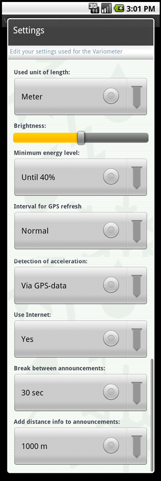
Define the unit to use for visibility
Choose from meter or foot.
Define the display brightness used
in online mode.
If the device reach this battery level.
the online mode will be stopped.
So your are able to use your phone
i.e.: in case of emergency.
Low update rate safe device energy,
a high rate ensure realtime sensor,
information, but consume a lot of energy.
Normal is a good compromise.
Accesloraton can be detected via GPS
or via device internal sensors (g-Sensor, pressure).
Using g-Sensor you must ensure the correct
device orientation (upright). GPS is bias
independent, but deliver a variable accuracy.
Recommended is usage of pressure, it delivers
best values for vertical speed (climb rate).
For online mode it's interesting to stop
internet access (for earth altitude update)
in case of rooming costs for your mobile device.
Define the intervall for speech information
regarding the orientation to the endpoint.
Define the distance border from than the
speech information should contain also
the distance to the endpoint
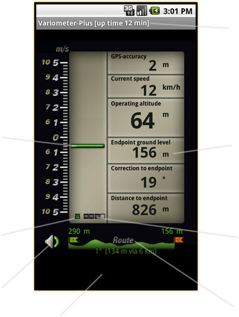
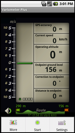
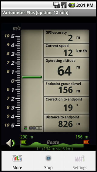
Display in online mode the uptime
Indicate the particular analog value.
Click to choos between several
measure devices.
Indicator for internet
(activated or deactivated)
Signal strengh of gps signal
available in online mode
Click to toggle sound
available in online mode
Visualize the current selected route.
Click to choose a new one in offline mode.
Visualize the selected sensor values.
Click on each value to select your
prefered values.
Please be carefull, this App
isn‘t a substitution for a real variometer such as a device from Bräuniger or FlyTec - usage is at your own risk.
Generally usage:
The intention of application usage.
Offline mode:
Set the route parameter and the personal view.
Settings:
Define the setting for the device.
Online mode:
View and listen to the particular measurements.
Realtime view
(more...):
View your current position
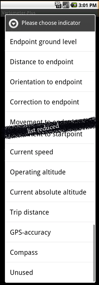
Click to the particular value
and choose the concrete
indicator from the available list,
like you want to see.
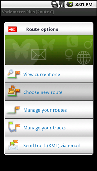
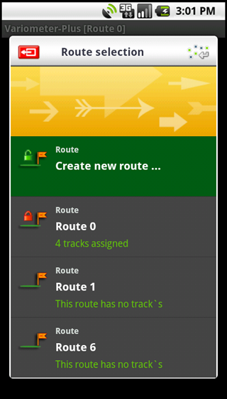
Choose in offline mode several route options:
Create or switch routes, view track details...
Switch between routes or create a new one:
View each route by click on the left 'route' icon
or click the text to select the route and press overtake (press menu or use top-right icon)
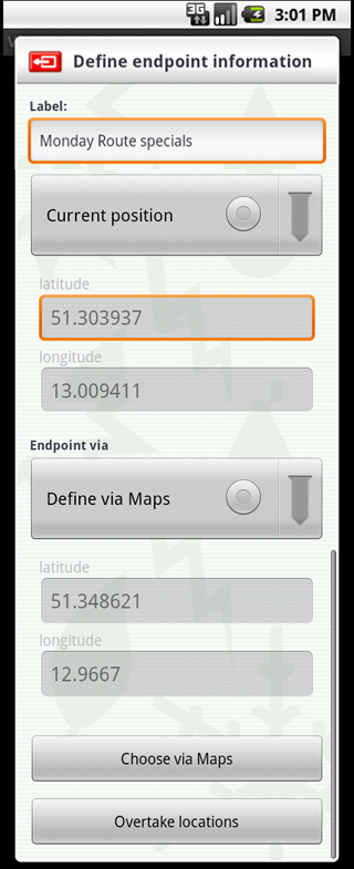
Choose the route points:
Set the startpoint and the endpoint for the trip
Select the route points via map:
For comfortable handling use goole maps ...
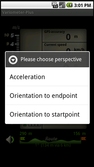
Choose the analog perspective,
and implicide the speech content.
| |
Finally some very useful hints:
|
|
| |
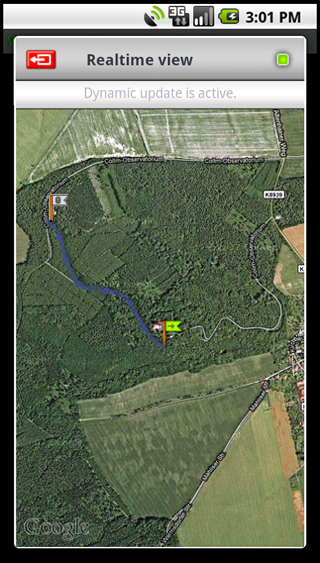
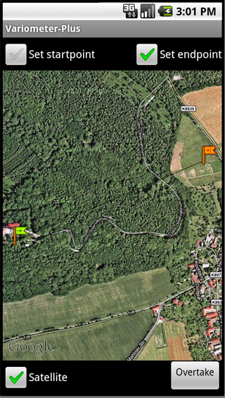
- What means realtime-view: (more...)
The Realtime view draws both the start
and endpoint and each gps position of your
current track in online mode. You can zoom
the view and toggle between map and satellite
view. The Gps-accuracy is visible as an blue
circle arround your position.
|
|
|
| |
- How to choose the route:
Click in Offline-Mode on the route symbol,
define the endpoints via Map or direct input
and overtake the locations. If internet is
allowed the altitudes from the earth model
will be requested, and your route is ready
for take off. You can switch between
already created routes without internet
altitude update.
|
|
|
| |
- What? My track's in Google Earth: (more...)
To review your tracks (courses) in google earth
on your PC click in offline mode on the route
symbol to open the "Route options" view and
choose "Send track(KML) via email". The selected
tracks are automatically zipped together and
can be send to your email account.
Note: You can also send the current realtime
track in online mode in the same way. Check
in online mode the "More" menu point and
select "Send Realtime-Track"!
|
|
|
| |
- Is there a way to review my track's in the app:
Yes!. Simply click in offline mode the route symbol,
and select track management. Click on each left
icon and review your track. Additonally summary
infos like way or time will be available too.
|
|
|
| |
- Why should I disable internet:
If your outdoor journey is not located
in your country you MAY like to avoid
rooming costs from your mobile carrier.
However in case of internet deactivation
some senors (like Operating altitude,..) are
not available, due to missing internet link.
|
|
|
| |
- Howto handle device energy consumption:
Using settings dialog you can define the GPS
refresh rate and gives you the comfort of
selecting free. The 'Normal' profile should deal
good for general purpose. Additionally the menu point
"Deactivate Display" set the display into an
dark mode, and reduce the consumption of battery power.
|
|
|
| |
- Why does the indicator for the GPS signal strength rotates:
Normally an excelent signal strenght is indicated by
four grey'ed led's and a poor signal by only one.
In case of gps aquiring or loss of signal the four
indicators are rotating and blinking.
|
|
|
| |
- What means the color of the analog device:
To visualize the displayed analog value additionally
the color of the arrow will be changed.
dark green: current vertival speed (climb rate).
orange: correction angel to endpoint.
light green: correction angel to startpoint.
(aligned to the flags indicating the start/stop)
|
|
|
| |
- Why there are several climb rate value sources:
Using GPS sensor data enables you to "calulate" the
climb rate. But GPS contain in any case a SA
(selective availability), means a build in
measurement error. If your device contain internal
sensors, its recommended to choose this source.
Based on the build in hydrostatic sensor the change
of vertical speed (climb rate) is calculated.
If your device do not support the barometer the
second option is the usage of build in g-Sensor
(g=acceleration). Currently the device must stay
or hang in face to the user, when using the g-Sensor.
Using the hydrostatic sensor you can use the
device as much as comfortable.
|
| |
- What means NAN at hyrostatic pressure in Online-Mode:
You can select the indicator value from
the list of 17 different measure values.
If your device do not contain a barometer
the NAN value will be displayed.
|
|
|
|
|
| |
|
|
| |
|
|